Here's the web-version of the finished
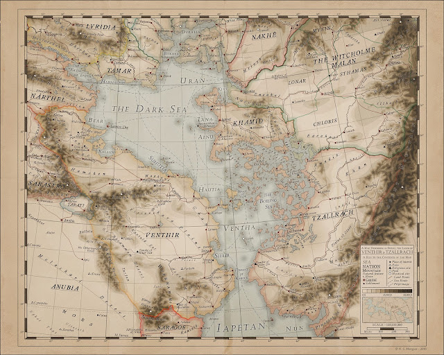
Venthir and Tzallrach map I was working on. In the end I Settled on a different style for the mountains that what I had been thinking of. I'm happy with these though would still like to try and perfect the hatchure style as that's what I want to use on my atlas.
This coloured contour style is probably a tad too modern for the world (especially the date depicted on the map) though I like it. You might notice the lack of proper contour colours (no greens for instance). I'm not sure I want to add those as they might make it look too modern.
Please let me know what you think!
 |
| A Map of Venthir and Tzallrach |
EDIT: I noticed there were some fragments around some of the mountain text so removed it and added a n elevation key to the cartouche to give an idea of the heights. I also want to add spot heights to the peak icons (white triangles) to show how high that point is, though that can wait!
More details on Venthir can be found
here.
#Elyden #fantasycartography, #worldbuilding

Very nice. The picture quality is very clear, and i like the names of some of the structures. Nasa mountains. Loved it. Do you have cultural boundaries, economics and small details on some of the areas which can be traveled to? As well as how do the seasons affect the continent? Monsoons don't seem to be an issue but earthquakes? Sorry if I got carried away.
ReplyDeleteChris
Hi there, I love questions like this as they make me think of some things that I might otherwise have missed out.
DeleteI have a document (the Encyclopaedia Elyden) which I edit with world details as I come up with them. So far i Have the general history, covering about 6,000 years, of the area (concentrating on Venthir) fleshed out, though other areas are less detailed. I'm not sure if you were looking at anything in particular?
Given the latitude, Monsoon isn't an issue, though you are correct in thinking that earthquakes are, particularly in the S of Venthir and Tzallrach, where geological activity around the mountains is relatively common.
Thanks for the questions and don't be ashamed to keep them coming :)
encylopaedia Elyden - http://vorropohaiah.blogspot.com.mt/2015/05/the-encyclopdia-elyden.html
Venthir history - http://vorropohaiah.blogspot.com.mt/2014/03/venthir.html
Hi, Do you do tutorials? Im interested in how you achieved the antique look. Awesome work btw!
ReplyDeleteHi, the colours were chosen intentionally to evoke an older look. Once the map was finished I added some noise and an old paper texture to reinforce the old feel.
Delete